Wednesday, June 24, 2009


By Marty Basch
Sucker Brook sounded like it wouldn't be that easy to find. But the directions were coming from a man who knew it well.
"There's a launch past the marina," said Tom Henderson over the phone. "Put in there, paddle through the Narrows, go under the bridge and head due north."
Sometimes it's easier said than done.
Patience please
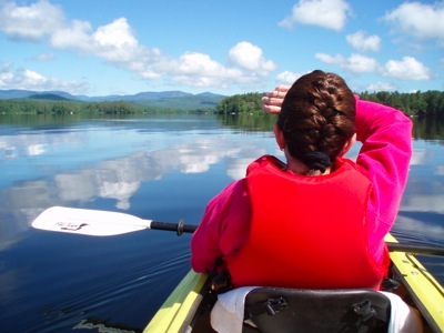
But with a little patience, Henderson's directions were spot on and led to a special quiet place loaded with birds like herons, red-winged blackbirds and even an eagle.
Sucker Brook is a winding channel in Kezar Lake's Lower Bay in the western Maine town of Lovell. It has the same name as a hiking area a few miles away, but this Sucker Brook is a place to paddle. Under the protection of the Greater Lovell Land Trust, it's a marshy wetland area that Henderson visits a lot as executive director of the trust which oversees about 1,800 acres of wetlands and forests not far from the New Hampshire border.
Before hanging up, he said, “Don't forget to look up.”
Nine-mile long Kezar Lake is a summer hot spot for boaters which might cause flat-water lovers to paddle elsewhere. Lower Bay, at the lake's southern end, certainly has all sorts of watercraft and plenty of camps, cottages and docks along much of its shore. However, after a steady 40-minute paddle the reward is a soothing heavily forested off-the-beaten path waterway underneath the rocky ledges of the Baldfaces up through Evans Notch.
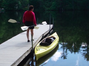
Motoring into Fryeburg, Maine, the drive went by the town's fairgrounds along Route 5 to small town Lovell and West Lovell Road before turning on Town Beach Road past the marina to the boat launch.
Due north
Due north meant hugging the shoreline and a few strokes into the paddle a loon appeared as if to say "right this way you tandem paddlers." Through the lean Narrows and under the bridge we went before reaching a wide expanse of the Lower Bay. The lesser traveled peaks and hills of Evans Notch were strung out on the horizon.
Unlike hiking or bicycling, we had no detailed map or guidebook to show us the way. We did have "The Maine Atlas and Gazetteer" which clearly showed Lower Bay, the wetlands and Sucker Brook, but on the water there aren't trail or road signs to assuage the anxiety that comes with being in unfamiliar territory. We left the shoreline and headed for what looked like wetlands beyond all those homes.
Lake topography can be tricky with coves and islands masking themselves as shoreline before revealing their true selves the closer one gets. Through the binoculars other marshy, unsettled areas appeared and we got back on a northern course.
A sign, of sorts
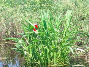
There was no sign but we knew we were in Sucker Brook when we saw a sort of sign: a red reflector stuck in some weeds. The smooth as glass bay was left behind for the lilies not yet blooming, shrubs and the birds. The red-winged blackbirds were hovering, hunting insects they would snatch out of the air. Herons stood like sentries in the weeds as we paddled by.
The curved passageway was wide, and didn't enter into a maze. We paddled in for a good half hour before deciding to return.
That haze of the unknown lifted as were now in familiar waters and we kept our eyes on the sky remembering Henderson's sage advice. There above the tall pines a white-crowned eagle soared as my partner Jan peered through her binoculars. Easy to spot against the blue sky, it took cover perched in the trees only to take off again. The bird dove down to the water as if to snag a fish, only to pull up abruptly and continue flying.
The wind rose up a bit as we stayed near the shore. As we paddled under the bridge for the final strokes of the journey, a loon appeared on the surface. He sized us up and then darted under the water in search of something more interesting. Maybe it was the same loon that saw us start out and wanted to make sure were okay following those first-rate directions.
One Tank Away
Lovell is:
Copyright 2009 Marty Basch
Copyright 2009 Marty Basch
Copyright 2009 Marty Basch