Thursday, June 11, 2009


By Marty Basch
Approaching Katahdin from the west, Charlie Cirame had scrambled his way above treeline. The work glove on his right hand was proper protection from the tricky, harsh boulders along the trail and he stopped along the alpine moonscape to admire not only the highest peak in Maine, but those it dwarfs.
“The mountain has so many faces,” said Cirame, a former Millinocket mill worker. “I’ve been looking at it for 28 years and it’s never the same.”
How true. Silence is followed by an ear-numbing beat, that of a hiker’s heart. The weather can change dramatically and drastically. Severe winds above treeline can stop travel, as Pamola, the man, eagle, moose Penobscot storm god guards the terrain along the mile-high mountain.
The “Greatest Mountain,” as the Penobscot Indians called it, can also stand below stunning blue, windless skies, the sun radiant in Maine’s remote North Woods. Humbling and gratifying, Katahdin is the most challenging, strenuous and remote of New England’s high points.
Baxter State Park
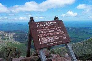
Glacial cirques called basins, vast flats on the tablelands, steep pitches and razor-like ridges comprise Katahdin’s domain of forest, lakes, ponds and rivers in Baxter State Park near Millinocket. The mountain stretches out for four miles and it is Katahdin at 5,276 feet that is the roof of Maine. Okay, so a towering cairn at the summit makes it a mile high.
The 200,000-plus acre park has narrow dirt roads and no running water or electricity. The campgrounds fill up quickly.
With 46 peaks and ridges, 18 of them above 3,000 feet, it is still Katahdin with its array of summit options that is the draw of Baxter through the gates of the southern Togue Pond entrance.
The plan
The plan was to hike Katahdin from the east, making a loop from the Roaring Brook Campground along the Chimney Pond Trail, up through the basin on the Saddle Trail and return to Chimney Pond along Cathedral. Cirame, who I had met in the fall of 2000 during a Baxter to Georgia bicycle trip, had climbed Katahdin about 30 times and suggested the easiest route up the mountain.
But at the park entrance, the gatekeeper pointed to a sign. The Saddle Trail was closed. Too much snow and ice. And this was June.
Plan B
So Plan B was quickly hatched. The precarious, narrow Knife Edge Trail, where the ridge spans just about three feet in places, was quickly vetoed. Neither of us wanted to do battle with the steep slide on the Abol Trail, so the decision was made for a 10.4 mile roundtrip all-day workout on the Hunt Trail: the last five miles of the Appalachian Trail.
Katahdin is the northern terminus of the 2,168 mile Maine to Georgia white-blazed AT. Park visitors in fall are likely to share the footpath with hardened and weather-beaten thru-hikers who started in April from Georgia’s Springer Mountain and are finishing their intrepid walk through the woods.
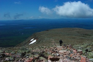
Even at 7:22 a.m. we weren’t the first ones on the trail that day. The weather forecast called for partly sunny skies throughout the day. Carrying water and packs with food, guidebook, foul weather gear, matches, flashlight and other emergency items, we headed up through the spruce-fir forest along the flowing Katahdin Stream. Pink and gray granite boulders littered the woods, pink becoming dominant as after three miles the climb bursts out above treeline on a boulder-laced spur. Climb, squeeze, grab and scrape through the sardine tin of rocks, a few iron holds in place for leverage.
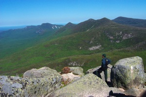
The dizzying bird’s eye view of birds in the thermals sees them above the ponds and mountains below. Two granite slabs signal the “gateway” where the terrain relatively levels out on the flat treeless tablelands desert.
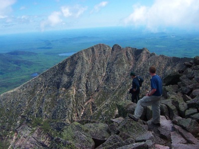
From the summit, Katahdin shows another face. The spectacle of the Great Basin and serrated ridge of the mile-long Knife’s Edge share the horizon with northern ponds and rivers.
Ground floor
We started down, meeting Nelson Daigle, a retired Millinocket mill worker who uses Katahdin as an outdoor gym. On this day he was on climb 184 of the mountain.
“A lot of people think going down is harder,” he said. “Going up is harder on the lungs. Going down is harder on the knees.”
Passing a trail crew out restoring knocked down cairns, Cirame was quick and agile on those spur-exposed rocks, while a few hikers - including myself - preferred the butt slide approach in a few places, gingerly taking leaps of faith.
After nine hours of hiking, the ground finally returned to a horizontal position signaling the end to a well-appreciated Plan B.
One Tank Away
Millinocket is:
-
*230 miles from Berlin, N.H.
-
*374 miles from Bellows Falls, Vt.
-
*286 miles from Lawrence, Mass.
Copyright 2009 Marty Basch
Copyright 2009 Marty Basch
Copyright 2009 Marty Basch
Copyright 2009 Marty Basch